A true taste of Victoria

Experience some of Victoria’s most spectacular mountain summits and historic high country huts.

Getting to the Buller Huts Trail
Mount Buller Alpine Resort
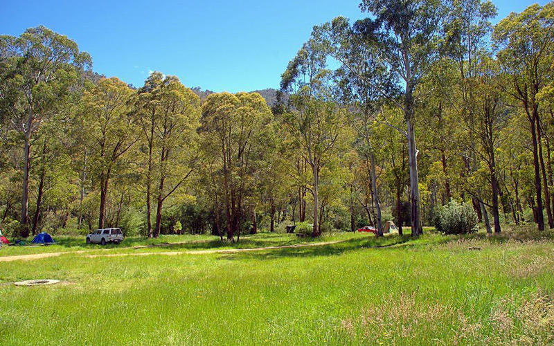
The Buller Huts Trail begins at Mount Buller, a popular ski resort in the Victorian Alps. The trailhead is accessible by 2WD in summer, but chains are required in winter. A car park is available on Summit Road near Village Square, but it can get busy on weekends during the peak season. Bring your own food and supplies, as Mt Buller has limited facilities. Mansfield is the closest town with supermarkets, cafes, and pubs.
The recommended trailhead is opposite Georges along Athletes Walk. However, as this is a circuit hike, you can start and finish the trek wherever you choose. Opting to kick off within the Buller Alpine Resort is advisable primarily for the convenience of vehicle access. Although the trail offers various access points throughout the year, many of these can only be reached via 4WD, with some inaccessible during the winter months.

Day 1: Mount Buller to Eight Mile Flat
Length: 17.5km
Duration: 8-9 hours
Grade: 5 (Difficult)
Day 1 includes a long descent along a narrow trail down 4 Mile Spur, followed by a crossing of the Howqua River at the foot of the Spur.The river can be fast-flowing and deep following heavy rain or snow melt, so it is important to check the conditions before crossing.
The Buller Huts Trail commences on Mount Buller, high in the Victorian Alps, at an altitude of just over 1660m and traverses some of Victoria’s most spectacular mountain summits. These include: Mount Buller, The Bluff, Mount Eadley Stoney, Mount Lovick, Mount Magdala, Mount Howitt, Mount Buggery, Mount Speculation, Mount Koonika, The Monument and Mount Stirling.
The recommended trailhead is opposite Georges along Athletes Walk. However, as this is a circuit hike, you can start and finish the trek wherever you choose.
Starting at the junction of Athletes Walk and Summit Road, follow Summit Road west for around 600m to the carpark. The Summit Nature Walk starts here. Follow the trail as it twists and turns in a westerly direction towards the summit of Mount Buller (1805m).
From the summit, retrace your steps a short distance to the carpark at the end of Summit Road. Turn right to continue on the Summit Nature Trail. After a short distance, turn southwest at the junction of Wombat Access and head down Family ski run. Turn onto Zwiers Zigzag (signed) and the start of 4 Mile Spur.
The trail now descends along this often narrow spur for approximately 6.5km to the Howqua River below. On reaching the foot of 4 Mile Spur, cross the Howqua river to Gardiners Flat and pick up the Howqua River High Path.
A short distance east of the Howqua River, you will enter a large, flat, grassy area where you will find Gardiner’s Hut (also known as Four Mile Hut). This hut is private and requires a key from the owners to use, so I have not included it on the huts overview page or GPX files. The hut is commonly used for search and rescue or other emergencies.
Turn east and follow the Howqua River High Path, then Brocks Road, for 6.5 km through Seven Mile Flat to Eight Mile Flat, an excellent campsite on the riverbank.
If your itinerary permits, there is an optional 12km return side trip that commences at Eight Mile Flat and follows the Howqua River east to Ritchies Hut.
You can reach Richies Hut via the Low Track or the High Track. The Low Track has 12 river crossings, so if the Howqua River is high or you prefer to keep your feet dry, the High Track is the better option. You can also hike to Richies Hut on one track and return on the other for a loop hike.
Ritchies Hut is conveniently located on the Howqua River with adequate, open camping areas around the hut if you choose to stay overnight. My suggestion is to set up camp at Eight Mile Flat and take enough supplies to make this a return day hike.
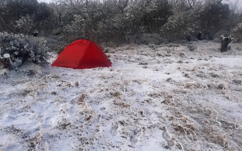
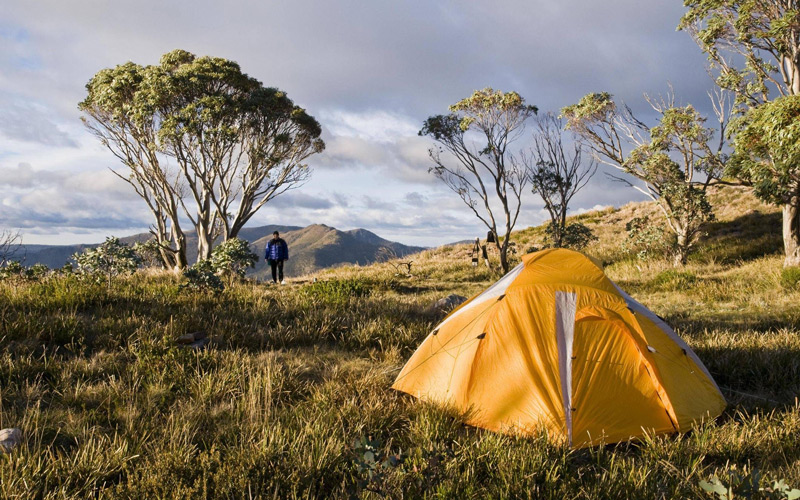
Eight Mile Flat. An excellent camp site on the banks of the Howqua River with a relatively large clearing (an old hut site). This is a pleasant, level and grassy site with long-drop composting toilet and fire pits.
Water is available from the Howqua River at Eight Mile Flat.

Day 2: Eight Mile Flat to Bluff Hut
Length: 12.5km
Duration: 8-9 hours
Grade: 5 (Difficult)
Day 2 includes a long, steep ascent along a narrow trail up 8 Mile Spur. Steep and rocky scrambling/climbing is required at the top of the spur in order to reach the Bluff.
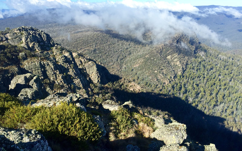
From a pleasant grassy clearing beside the Howqua River, the trail climbs steadily through dry open forest along Eight Mile Spur. The final stages of the ascent to the rugged natural ramparts of the Bluff are quite steep, but the rewards are soon evident. From the treeless 1,725 metre summit, a spectacular alpine panorama unfolds, stretching to Mount Buller in the north and faraway Lake Eildon.
The trail continues through alpine meadows, carpeted with brilliant wildflowers in early summer, to Bluff Hut and a sheltered campsite among the nearby snow gums.
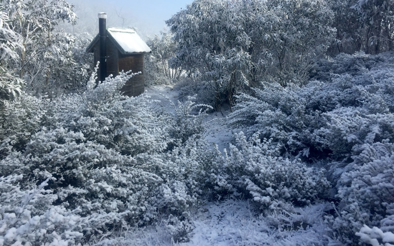
Bluff Hut has a large open area opposite the hut which is perfect for pitching your tent. There is also bush camping among snow gums within a few hundred metres of Bluff Hut. A composting toilet is also available adjacent to the large open area.

Day 3: Bluff Hut to Hellfire Creek
Length: 13.5km
Duration: 8-9 hours
Grade: 4-5 (Hard-Difficult)
Day 3 includes a long but relatively flat walk along 4WD tracks, followed by a steep ascent of Mount Magdala via a rough and often rocky walking trail.
Follow Bluff Track east from Bluff hut over the summit of Mount Lovick (1684m) for approximately 5.6km to the junction of Lovick Hut Trail. Leave Bluff Track at this point and descend to Lovicks Hut.
Approximately 1.2 kilometers north of Lovick’s Hut, you will reach the junction of Helicopter Spur. This is one of the steepest spurs in this region and a rewarding hike in its own right. Turn east at this point and continue along Bluff Track, past Picture Point (with spectacular views) and on to the junction of the Australian Alps Walking Trail (AAWT). Follow the trail in a north-easterly direction towards Mount Magdala, traversing one of the best sections of the long-distance AAWT.
Descend past Hells Window to the saddle between Magdala and Big Hill where you will find Hellfire Creek, an open grassy campsite among the snow gums.
If you are feeling energetic and want to bag a few extra peaks, there is an optional side trip, just beyond Picture Point, that heads south along a ridge line to the summits of King Billy No 1 and King Billy No 2. The short walk follows a section of the Australian Alps Walking Track (AAWT) to to a small plateau and rock cairn at the summit. The return journey is approximately 3.6km so I would suggest leaving your packs behind.
The Hells Window campsite is located on a broad saddle east of Mount Magdala and west of Big Hill. This is a large flat and sheltered site amongst the snow gums, close to Hellfire Creek. There are no toilets available at this site.
Day 4: Hellfire Creek to Camp Creek
Length: 13.5km
Duration: 6 hours
Grade: 4-5 (Hard-Difficult)
Day 4 includes a long and steady ascent of Mount Howitt (1742m), followed by a rough and undulating traverse of the Cross Cut Saw. The section from Mount Buggery via Horrible Gap to Mount Speculation (1650m) is challenging and requires rock scrambling on steep, loose and uneven terrain.
From Hellfire Creek campsite, continue along the trail, which heads north-east, towards Mount Howitt. Take the time here to soak up the views across the Crosscut Saw to the north before descending Mount Howitt to the junction of the Crosscut Saw and Mount Howitt Walking Track. From this point, head directly east to Macalister Springs and the Vallejo Gantner Hut.
Macalister Springs is a very reliable water source and worth a visit if you were unable to locate water the night before. Return via the same route to the junction of the Crosscut Saw. The Crosscut Saw is a scramble along a narrow ridge and is not for those with a fear of heights. This traverse will lead you over the summit of Mount Buggery, through Horrible Gap, and to the broad summit of Mount Speculation.
Continue over the summit, heading north-east, and descend to Speculation Road and a reliable water source and campsite at Camp Creek.
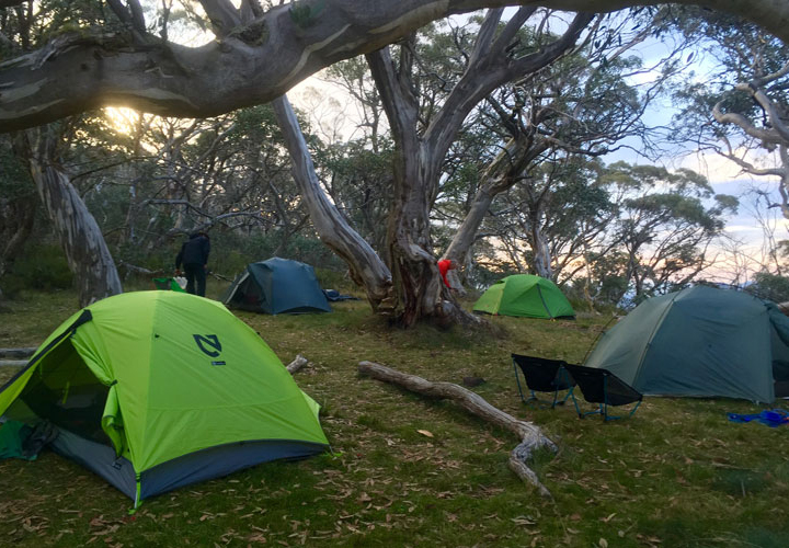
One campsite at Mount Speculation is located just near Camp Creek. There is also an additional site on the approach to Mount Speculation summit. Select your preferred site depending on the conditions as the one nearer to Speculation is slightly more exposed. Mount Speculation is renowned for being one of the finest campsites in the high country. There are no toilets available at this site.
Day 5: Camp Creek to King Hut
Length: 12.5km
Duration: 6 hours
Grade: 4 (Hard)
Day 5 begins with a section along Speculation Road that is relatively easy going initially, however the descent along Muesli Spur, via the Staircase, follows a narrow walking trail, which is steep, rocky, and requires careful navigation on several steep and rocky sections.
Heading north-north-west, continue along Speculation Road for approximately 7.2 kilometers and locate Muesli Spur to the west. The trail along the spur is reasonably well-worn and should be easy to follow as it descends steeply towards the King River in the valley below.
At the end of Muesli Spur, you will again intersect Speculation Road. Turn left (almost straight ahead) at this point and follow Speculation Road then King Basin Road for approximately 1.4 kilometers until you reach King Hut and an open grassy campsite.
If your itinerary permits, there is an optional, 11km return, side trip that commences at the junction of Muesli Spur and Speculation Road that leads you to the unique rocky summit of Mount Cobbler. From Muesli Spur, continue north along Speculation Road/Lake Cobbler Track for approximately 1km before you will need to locate a foot trail that will lead you north across the plateau to the summit of Mount Cobbler. There are two rocky summits your can attempt. The northern most of these is a lot more challenging than the main summit.
I’d recommend making this an overnight side trip. There’s an excellent, flat open camping area (no water) approximately 1.5km before reaching the summit at the junction of the Mount Cobbler Walking Track. My suggestion is to set up camp before attempting the summit.
I would not recommend attempting the journey from Speculation Road, to Mount Cobbler and through to King Hut in one day as that would be close to 24km.
The King Hut camping area is an excellent camp site on the banks of the King River. This is a large, level and grassy site with long-drop composting toilet and fire pits.
Day 6: King Hut to Craigs Hut
Length: 13.5km
Duration: 6 hours
Grade: 3-4 (Moderate-Hard)
Day 6 includes a long but relatively flat walk along a 4WD track with five river crossings. The ascent along the McCormacks Trail spur is long and steady before reaching Craigs Hut.
Follow King Basin Road north-west for approximately 6.4 kilometers and locate McCormacks Trail on the south side of the road. Follow the trail along a broad spur for 3.2 kilometers to the junction of Circuit Road. Turning left, follow the road a short distance (200 meters) to continue your ascent along McCormacks Trail.
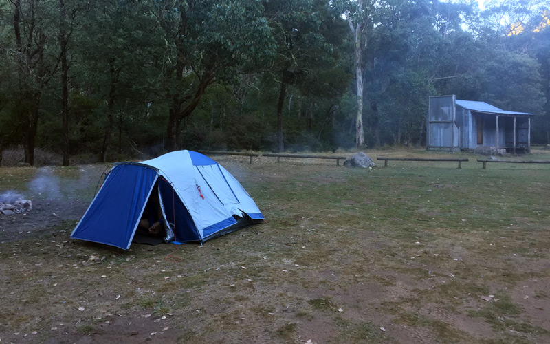
After approximately 1.7 kilometers, you will again reach Circuit Road. Turn right at this point and follow the road for 1 kilometer, where you will locate the Craigs Hut Walk on your left. Follow this trail to the top of the knoll and Craigs Hut. Nearby you will find grassy flats for camping, fire pits, and toilet facilities.
Note: McCormacks Trail is fairly well defined but not signed anywhere and has a lot of blackberry infestation. Some people follow an alternate route to from King Hut to Craigs Hut. This ascends along from King Hut on a well-defined trail and avoids the five creek crossings.
McCormacks Trail is fairly well defined but not signed anywhere and has a lot of blackberry infestation. Some people follow an alternate route to from King Hut to Craigs Hut. This ascends along from King Hut on a well-defined trail and avoids the five creek crossings.
An large, open camp site a short distance from Craig’s Hut, down Clear Hills Track. This is a pleasant, level and grassy site with long-drop composting toilet (near Craig’s Hut). There are no fire pits in this camp ground.
A rainwater tank near to Craigs Hut provides water, but availability is uncertain. Rainfall and recent usage can affect water levels. It is wise to inquire on forums or contact Parks Victoria in Mansfield for information.
Day 7: Craigs Hut to Mount Buller
Length: 13.5km
Duration: 6 hours
Grade: 3-4 (Moderate-Hard)